Poster Map. Kings Cross St Pancras. Street plan of area around St Pancras and Kings Cross Stations, London, showing entrances to underground station. June 1939. Ref: 39/5466/GX/100 (based upon the Ordnance Survey map). Printed by Stanford's Geographical Establishment, London. Format: double royal. Dimensions: 40 x 25 inches, 1016 x 635mm. King's Cross St Pancras map 1939
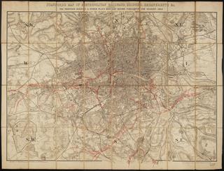
Stanford's New Map of Metropolitan Railways and Miscellaneous Improvements, sanctioned in 1866; also the Railways in Operation, and those Sanctioned before 1866, as far as Croydon, Hounslow, and Barnet; with a list of the plans [printed map] / Edward Stanford (publisher, 6 Charing Cross, London). 1866 Sept. 1 sheet folded within boards. Scale 2" : 1m. Post sessional edition] Stanford's New Map of Metropolitan Railways and Miscellaneous Improvements, sanctioned in 1866 .... 1866
Diagram, the astral cipher emblems of the signs of the zodiac. Diagram, the astral cipher emblems of the signs of the zodiac